File:Stars 01 (MK).jpg
From AnthroWiki

Size of this preview: 800 × 264 pixels. Other resolutions: 320 × 105 pixels | 640 × 211 pixels | 1,024 × 337 pixels | 1,280 × 422 pixels | 6,070 × 2,000 pixels.
Original file (6,070 × 2,000 pixels, file size: 8.43 MB, MIME type: image/jpeg)
.
Summary
| Description |
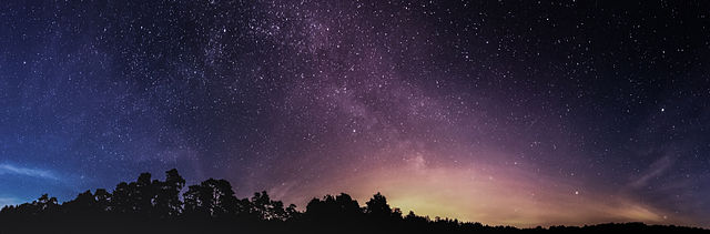
Deutsch: Teil des Sternenhimmels (~280°) bei Brandenburg an der Havel um Mitternacht. Panoramabild aus 14 Einzelbildern.
English: Part (~280°) of the starry sky near Brandenburg an der Havel (Germany), close to midnight.
Español: Vista de una parte (~280°) del cielo estrellado hacia medianoche, cerca de la Ciudad de Brandeburgo, Alemania.
Polski: Wycinek rozgwieżdżonego nieba o szerokości około 280° w pobliżu Brandenburga an der Havel w Niemczech sfotografowany około północy.
Čeština: Noční hvězdná obloha s identifikací řady objektů nad německým městem Brandenburg an der Havel, (Braniborsko), v době kolem půlnoci.
Italiano: Il cielo stellato nei pressi di Brandeburgo sulla Havel verso mezzanotte
한국어: 자정 가까운 시각, 독일 브란덴부르크안데어하펠 인근의 별빛 하늘 일부분(~280°).
Português: Vista de uma parte (~280°) de céu estrelado, perto da cidade de Brandemburgo no Havel, Alemanha. |
| Date | |
| Source | Own work |
| Author | Mathias Krumbholz |
| Other versions |
.jpg) |
| Camera location | | View this and other nearby images on: OpenStreetMap |
|---|
Assessment
|
This image was selected as picture of the day on Wikimedia Commons for 29 June 2018. It was captioned as follows: English: Part (~280°) of the starry sky near Brandenburg an der Havel (Germany), close to midnight Other languages:
Čeština: Noční hvězdná obloha s identifikací řady objektů nad německým městem Brandenburg an der Havel, (Braniborsko), v době kolem půlnoci. Deutsch: Teil des Sternenhimmels (~280°) bei Brandenburg an der Havel um Mitternacht. Panoramabild aus 14 Einzelbildern English: Part (~280°) of the starry sky near Brandenburg an der Havel (Germany), close to midnight Español: Vista de una parte (~280°) del cielo estrellado hacia medianoche, cerca de la Ciudad de Brandeburgo, Alemania. Italiano: Il cielo stellato nei pressi di Brandeburgo sulla Havel verso mezzanotte Polski: Wycinek rozgwieżdżonego nieba o szerokości około 280° w pobliżu Brandenburga an der Havel w Niemczech sfotografowany około północy. Português: Vista de uma parte (~280°) de céu estrelado, perto da cidade de Brandemburgo no Havel, Alemanha. 한국어: 자정 가까운 시각, 독일 브란덴부르크안데어하펠 인근의 별빛 하늘 일부분(~280°). |
Licensing
| Feel free to use my photos, but please mention me as the author and if you want send me a message. |
I, the copyright holder of this work, hereby publish it under the following license:
This file is licensed under the Creative Commons Attribution-Share Alike 3.0 Unported license.
- You are free:
- to share – to copy, distribute and transmit the work
- to remix – to adapt the work
- Under the following conditions:
- attribution – You must give appropriate credit, provide a link to the license, and indicate if changes were made. You may do so in any reasonable manner, but not in any way that suggests the licensor endorses you or your use.
- share alike – If you remix, transform, or build upon the material, you must distribute your contributions under the same or compatible license as the original.
| Annotations | This image is annotated: View the annotations at Commons |
File history
Click on a date/time to view the file as it appeared at that time.
| Date/Time | Thumbnail | Dimensions | User | Comment | |
|---|---|---|---|---|---|
| current | 13:00, 21 June 2014 | 6,070 × 2,000 (8.43 MB) | wikimediacommons>Leviathan1983 | -complete rework, more natural look |
File usage
There are no pages that use this file.

.jpg)
.jpg&action=edit&redlink=1)
.jpg)
.jpg¶ms=052.465752_N_0012.487623_E_globe:Earth_type:camera_alt:43.83_source:exif_&language=en)
.jpg)
.jpg)
.jpg)
.jpg&action=info)